Trail Walking La Garde-Adhémar - Le Val des Nymphes  - Photo
© OpenStreetMap contributors
Length
Length
12.4 km
Max alt
Max alt
232 m
Uphill gradient
Uphill gradient
259 m
Km-Effort
Km-Effort  
15.8 km
Min alt
Min alt
80 m
Downhill gradient
Downhill gradient
266 m
Boucle
Boucle
Yes
Creation date :
2023-04-09 07:53:35.0
Updated on :
2023-04-09 10:56:21.117

(0 Reviews)

Walking
Walking
2h46
Difficulty : Easy

Scan this QR Code to open this trail in the SityTrail application

FREE GPS app for hiking

Logo SityTrail SityTrail

IGN / Geographical institutes

Download SityTrail from the App Store Download SityTrail from Google Play

Logo SityTrail SityTrail World

The world is yours!

Download SityTrail from the App Store Download SityTrail from Google Play Download SityTrail on Huawei AppGallery

About

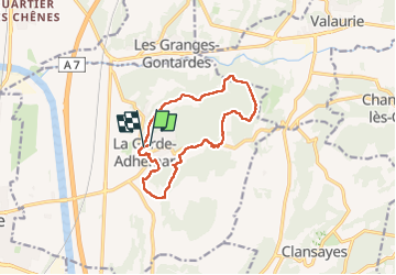
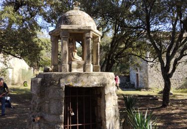
Trail Walking of 12.4 km to be discovered at Auvergne-Rhône-Alpes, Drôme, La Garde-Adhémar. This trail is proposed by alinetpierre.

Description

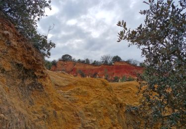
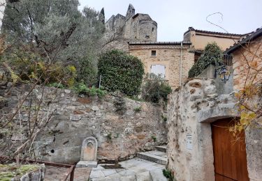
Très belle randonnée , de l’ombre, de l’eau

Elevation profile

Photos

Positioning

Country:
France
Region :
Auvergne-Rhône-Alpes
Department/Province :
Drôme
Municipality :
La Garde-Adhémar
Location:
Unknown
Start:(UTM)
639791 ; 4917195 (31T) N.

Trails nearby

Trail Walking Clansayes - SityTrail - Clansayes Le Rouvergue 6km - Photo
Walking
GUIDE
thonyc

Walking

Easy
(2)
Clansayes, Auvergne-Rhône-Alpes, Drôme, France
7.2 km | 8.4 km-effort
2h 0min
Yes
Trail Walking La Garde-Adhémar - La Garde-Adhemar Le Val des Nymphes Les Ocres 13km. - Photo
Walking
chancha

Walking

Difficult
(3)
La Garde-Adhémar, Auvergne-Rhône-Alpes, Drôme, France
12.6 km | 16.6 km-effort
3h 46min
Yes
Trail Walking Roussas - Roussas Panassas 8 km - Photo
Walking
chancha

Walking

Easy
(1)
Roussas, Auvergne-Rhône-Alpes, Drôme, France
7.8 km | 10.6 km-effort
2h 31min
Yes
Trail Walking La Garde-Adhémar - Autour de La Garde-Adhémar - Photo
Walking
GUIDE
thonyc

Walking

Medium
(1)
La Garde-Adhémar, Auvergne-Rhône-Alpes, Drôme, France
12.7 km | 16.7 km-effort
3h 45min
Yes
Trail Walking Clansayes - SityTrail - 2656269 - chantemerle-clansayes-15km - Photo
Walking
GUIDE
thonyc

Walking

Easy
Clansayes, Auvergne-Rhône-Alpes, Drôme, France
12.4 km | 15.8 km-effort
3h 0min
Yes
Trail Walking Valaurie - Valaurie Aiguebelle 16km - Photo
Walking
GUIDE
thonyc

Walking

Medium
Valaurie, Auvergne-Rhône-Alpes, Drôme, France
16 km | 21 km-effort
5h 0min
Yes
Trail Walking Clansayes - clansayes - Photo
Walking
cousam

Walking

Medium
(1)
Clansayes, Auvergne-Rhône-Alpes, Drôme, France
9.7 km | 14 km-effort
4h 49min
Yes
Trail Walking Valaurie - Boucle valaurie reauville - Photo
Walking
Perdrizet Pascal

Walking

Easy
Valaurie, Auvergne-Rhône-Alpes, Drôme, France
9.3 km | 11.7 km-effort
2h 5min
Yes
Trail Walking Clansayes - 2022-06-24_19h24m07_Clansayes Le Rouvergue 11km.gpx.xml - Photo
Walking
chancha

Walking

Difficult
Clansayes, Auvergne-Rhône-Alpes, Drôme, France
11.1 km | 14.5 km-effort
3h 21min
Yes


Close
My subscriptions